Japanese knotweed map: records near your postcode
Enter a postcode to see where knotweed has been recorded near you, from 86,778 records across England, Scotland and Wales. Every record comes from independent wildlife recording by botanists, local records centres, river surveys and the public, not from a treatment company's own jobs.
Where knotweed has been recorded
Knotweed has been recorded in 44.7% of 2 km squares in Wales, 35.5% in England and 11.2% in Scotland. It follows rivers, railways and roads, and is densest in the old industrial valleys of South Wales, the Pennine towns, Merseyside and London.
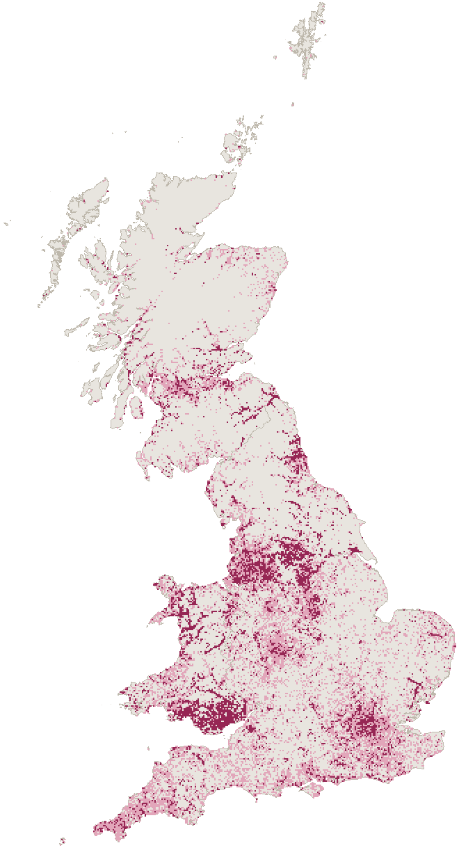
- Recorded since 2015
- Last recorded before 2015
- No record
| Nation | 2 km squares with a record | Records since 2015 |
|---|---|---|
| Wales | 44.7% (2,321) | 6,960 |
| England | 35.5% (11,575) | 26,284 |
| Scotland | 11.2% (2,193) | 1,770 |
Knotweed records by council area
38 council areas, including Wigan, Glasgow City and Bolton, have a knotweed record in every one of their 2 km squares. Search for yours to see how it compares.
| Council area | 2 km squares with a record | Records since 2015 |
|---|---|---|
| BoltonEngland | 100% (37 of 37) | 808 |
| ChesterfieldEngland | 100% (14 of 14) | 560 |
| St. HelensEngland | 100% (34 of 34) | 80 |
| LiverpoolEngland | 100% (28 of 28) | 219 |
| WiganEngland | 100% (48 of 48) | 157 |
| BrentEngland | 100% (12 of 12) | 27 |
| NottinghamEngland | 100% (20 of 20) | 41 |
| Glasgow CityScotland | 100% (46 of 46) | 37 |
| BuryEngland | 100% (24 of 24) | 188 |
| BroxtoweEngland | 100% (20 of 20) | 24 |
| SalfordEngland | 100% (23 of 23) | 70 |
| EalingEngland | 100% (15 of 15) | 13 |
| DudleyEngland | 100% (24 of 24) | 21 |
| SandwellEngland | 100% (21 of 21) | 14 |
| HounslowEngland | 100% (14 of 14) | 16 |
| WorcesterEngland | 100% (9 of 9) | 10 |
| LewishamEngland | 100% (8 of 8) | 52 |
| Barking and DagenhamEngland | 100% (9 of 9) | 9 |
| PlymouthEngland | 100% (20 of 20) | 9 |
| WolverhamptonEngland | 100% (17 of 17) | 15 |
Council areas in England, Scotland and Wales, ranked by the share of their 2 km squares with a knotweed record of any date. A square counts for the council its centre falls in.
What the records can and can't tell you
- A record means someone found knotweed there and reported it, usually with a check by an expert.
- No record doesn't mean no knotweed. Private gardens are rarely surveyed, and some counties have many more recorders than others.
- A stand recorded years ago may have been treated since, but knotweed seldom disappears on its own.
- Records are mapped to between a few metres and 2 km. The postcode tool shows only records mapped to 1 km or better, and says which is which.
Knotweed map questions
Where do the knotweed records come from?
From 71 datasets shared on the NBN Atlas, the UK's biodiversity database: the Botanical Society of Britain and Ireland's Plant Atlas and verified iRecord sightings, local environmental records centres, river and invasive species projects, the Environment Agency and members of the public using the INNS Mapper app. We use only records shared under open licences that allow it.
Why are there no records near me?
Records show where someone has found knotweed and reported it. Most private gardens are never surveyed, and some areas have far more recorders than others, so no record nearby doesn't mean there's no knotweed.
Does knotweed near my home affect selling it or getting a mortgage?
A record in the area doesn't, on its own. Surveyors follow the RICS standard, which looks at knotweed on the property and on neighbouring land within 3 m of the boundary. Our guide to Japanese knotweed treatment explains the four RICS categories and what lenders ask for.
Which area has the most Japanese knotweed records?
Of the three nations, Wales has the highest share of 2 km squares with a knotweed record, at 44.7%. Among council areas, 38 have a record in every one of their 2 km squares, and Kirklees has the most records since 2015. Busy recording projects in some areas push their numbers up, so treat rankings as a guide.
How can I add a knotweed record?
Record it with iRecord or the INNS Mapper app, with a photo. Verified records are shared with the NBN Atlas and will appear here when we next update the map.
How do I know it's really knotweed?
Use our knotweed identification checker, which asks about what you can see in the current season and compares your plant with the nine plants most often mistaken for knotweed.
Records of Japanese, giant and Bohemian knotweed from the NBN Atlas (nbnatlas.org), downloaded 3 November 2026, used under CC0, CC-BY 4.0 and the Open Government Licence; records under non-commercial licences are left out. Thanks to every recorder and data provider listed in the sources. Contains OS data © Crown copyright and database right.
Sources (76)
- NBN Atlas: occurrence records of Reynoutria (Japanese, giant and Bohemian knotweed)
- Plant Atlas 2020 - vascular plant and charophyte 2 x 2 km grid square locations, subdivided by survey period, up to 2019, Botanical Society of Britain & Ireland (CC-BY, 24,690 records used)
- INNS Mapper, Yorkshire Wildlife Trust (CC-BY, 20,550 records used)
- Vascular plant records verified via iRecord, Botanical Society of Britain & Ireland (CC-BY, 10,292 records used)
- Plant Atlas 2020 - vascular plant and charophyte 10 x 10 km grid square locations, subdivided by survey period, up to 2019, Botanical Society of Britain & Ireland (CC-BY, 8,394 records used)
- INNS Data: All Taxa (South East Wales), South East Wales Biodiversity Records Centre (CC-BY, 5,393 records used)
- Records of Invasive Non Native Species held on the Cofnod database, Cofnod - North Wales Environmental Information Service (CC-BY, 4,686 records used)
- Protected and Invasive Species Records Collected Through Environment Agency Survey 1995 - 2021, Environment Agency (OGL, 2,305 records used)
- INNS records held by BIS in Powys and Brecon Beacons National Park, BIS for Powys & Brecon Beacons National Park (CC-BY, 1,593 records used)
- England Non Native Species records 1965 to 2017, Environment Agency (OGL, 1,465 records used)
- North Merseyside Local Species Data (DEFRA Grant 23169), Merseyside BioBank (CC-BY, 971 records used)
- Nottinghamshire Non-Native Invasive Species Dataset, Nottinghamshire Biological and Geological Records Centre (CC-BY, 952 records used)
- Japanese knotweed controlled in 2022 as part of the Tweed Invasives Project, Tweed Forum (CC-BY, 688 records used)
- NRW Regional Data: South East Wales Non-sensitive species, South East Wales Biodiversity Records Centre (OGL, 575 records used)
- Non Native Species Across Wales (1989 to 2012), Natural Resources Wales (OGL, 557 records used)
- Flora of Worcestershire, Botanical Society of Britain & Ireland (CC-BY, 556 records used)
- Shropshire Ecological Data Network database, Shropshire Ecological Data Network (CC-BY, 533 records used)
- Invasive Non-native species data in the Clyde catchment, collated by Central Scotland Forest Trust, Central Scotland Green Network Trust (CC0, 290 records used)
- Dr Mary Gillham Archive Project, South East Wales Biodiversity Records Centre (CC-BY, 271 records used)
- Invasive non-native species records from SEWeb, Scotland's Environment Web (OGL, 269 records used)
- Fort William Knotweed, Lochaber Fisheries Trust (CC0, 251 records used)
- Argyll Biological Records Dataset, Argyll Biological Records Centre (CC-BY, 167 records used)
- River Macrophytes Database, Joint Nature Conservation Committee (OGL, 143 records used)
- Survey of giant hogweed, Japanese knotweed and Himalayan balsam on 5 major Lothian rivers, 2003/04, NatureScot (OGL, 125 records used)
- HBRG Invasive Non-native Plants Dataset, Highland Biological Recording Group (CC-BY, 122 records used)
- Natural Resources Wales Regional Data : Mid-Wales, BIS for Powys & Brecon Beacons National Park (OGL, 112 records used)
- R.H.Wardell - Cardiff Nature Conservation Strategy - 1991 - 1998, South East Wales Biodiversity Records Centre (CC-BY, 108 records used)
- KiEco Freshwater Ecology: River Macrophytes, Natural Resources Wales (OGL, 106 records used)
- NRW Regional Data: North Wales, Cofnod - North Wales Environmental Information Service (OGL, 75 records used)
- All taxa records for Leicestershire and Rutland, NatureSpot (CC-BY, 72 records used)
- NRW Regional Data: all taxa (excluding sensitive species), West Wales, West Wales Biodiversity Information Centre (OGL, 70 records used)
- A.T. Sumner's Records, The Wildlife Information Centre (CC-BY, 54 records used)
- National Trust Species Records, National Trust (CC0, 53 records used)
- National Trust for Scotland Species Records, National Trust for Scotland (CC-BY, 47 records used)
- Commissioned surveys and staff surveys and reports for Scottish Wildlife Trust reserves - Verified data, Scottish Wildlife Trust (CC-BY, 32 records used)
- Collection Specimens, Natural History Museum, London (CC0, 22 records used)
- Gloucestershire Historic Wildlife Sightings prior to 1st Jan 2000, Gloucestershire Centre for Environmental Records (CC-BY, 17 records used)
- Essex Wildlife Trust - Records, Essex Wildlife Trust (CC-BY, 15 records used)
- Patrick Roper’s Notebooks, Sussex Biodiversity Record Centre (CC0, 15 records used)
- Other BSBI Scottish data up to 2018, Botanical Society of Britain & Ireland (CC0, 13 records used)
- TWIC West Lothian Council - Local Biodiversity Site Surveys, The Wildlife Information Centre (OGL, 12 records used)
- BSBI data from several English counties, up to 2018, Botanical Society of Britain & Ireland (CC0, 12 records used)
- National Plant Monitoring Scheme - England, Scotland, Wales, National Plant Monitoring Scheme (OGL, 11 records used)
- Shire Group IDB species data 2004 to present, Shire Group of Internal Drainage Boards (OGL, 10 records used)
- Flora guardian survey records 2004 - 2013 for Scotland, Plantlife International (CC-BY, 9 records used)
- Invasive Non-Native Species, Outer Hebrides, Outer Hebrides Biological Recording (CC0, 8 records used)
- Phase 2 Woodland Survey of Wales, Natural Resources Wales (OGL, 8 records used)
- Survey and monitoring records for Scottish Wildlife Trust reserves from reserve convenors and Trust volunteers - Verified data, Scottish Wildlife Trust (CC-BY, 7 records used)
- Freshwater Shad Monitoring Data, Natural Resources Wales (OGL, 5 records used)
- RHS monitoring of native and naturalised plants and animals at its gardens and surrounding areas, Royal Horticultural Society (CC-BY, 5 records used)
- iRecord Surveys, Natural England (OGL, 5 records used)
- City of Edinburgh Natural Heritage Service - Ranger Patrol Records, The Wildlife Information Centre (OGL, 4 records used)
- Casual records for Scottish Wildlife Trust reserves - Verified data, Scottish Wildlife Trust (CC-BY, 3 records used)
- City of Edinburgh Natural Heritage Service - Ranger Ad-hoc records and sightings, The Wildlife Information Centre (OGL, 3 records used)
- Environmental Monitoring Database (EMD) Species data 1987 to 2015, Natural England (OGL, 3 records used)
- Malcolm Storey personal records and images, Malcolm Storey (CC0, 3 records used)
- Standing Waters Database - Scotland, NatureScot (OGL, 2 records used)
- TWIC Midlothian Council – LBS Site Surveys, The Wildlife Information Centre (OGL, 2 records used)
- City of Edinburgh Natural Heritage Service - Natural Heritage Service Data, The Wildlife Information Centre (OGL, 2 records used)
- Species within North Ayrshire from 1984 - Present, North Ayrshire Countryside Ranger Service (OGL, 2 records used)
- Stackpole National Nature Reserve Species Inventory and Ad-hoc Sightings from Across Pembrokeshire, Natural Resources Wales (OGL, 2 records used)
- Grassland Survey of Lochaber 1990-94, NatureScot (OGL, 1 records used)
- City of Edinburgh Natural Heritage Service - Historical Records, The Wildlife Information Centre (OGL, 1 records used)
- City of Edinburgh Natural Heritage Service - Easter Craiglockhart Pond and Marsh Survey., The Wildlife Information Centre (OGL, 1 records used)
- West Lothian Council - Consultancy Data, The Wildlife Information Centre (OGL, 1 records used)
- Site Condition Monitoring of river habitats, 2013: River Tweed LEAFPACS vegetation data, NatureScot (OGL, 1 records used)
- CEDaR Online Recording, Centre for Environmental Data and Recording (CC-BY, 1 records used)
- Nottingham Urban Wildlife Scheme iRecord download 2014 - 2017, Nottingham Urban Wildlife Scheme (CC-BY, 1 records used)
- Phase Two Lowland Heathland Survey, Natural Resources Wales (OGL, 1 records used)
- Survey records for Plantlife Nature Reserves from 1980-2016 in Great Britain, Plantlife International (CC-BY, 1 records used)
- 2017 North Devon Area of Outstanding Natural Beauty (AONB) Combe Martin Devon Bioblitz, Marine Biological Association (CC-BY, 1 records used)
- 2018 Marine Biological Association of the UK (MBA) Yealm Bioblitz, Marine Biological Association (CC-BY, 1 records used)
- Postcodes.io: postcode lookup (Ordnance Survey and ONS data)
- Office for National Statistics: Local Authority Districts and Countries (December 2025) boundaries
- Creative Commons Attribution 4.0 licence
- Open Government Licence v3.0